Newport, Rhode Island

As a city located on the shore, it is no surprise that Newport, Rhode Island had a harbor and an active trading port at the time of the revolution. The name of the city would be rather puzzling if, somehow, Newport in fact did not have any port to speak of. Although often overshadowed by much larger cities such as New York and Boston, examining the city layout as well as the correspondence of colonial leaders reveals that Newport served a vital economic role in colonial maritime trade networks.
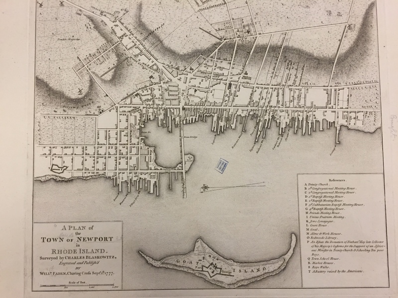
A brief examination of a map of Newport Rhode Island reveals that the city is clearly structured around the harbor. The importance of trade can also be perceived in the layout of Newport. All along the shoreline, the city is densely settled, however moving just one city block inland and the density of buildings rapidly decreases [1]. The central city square is also located adjacent to the waterfront and includes some of the most important buildings in the city, including the Market House and the Court House [2]. The proximity of the center of activity and power in the city to the docks indicates the central role the waterfront played in the function of the city.
Blaskowtiz’s map shows Fort George built on the crescent-shaped Goat Island in the western portion of the harbor. The scale on the map indicates that the fort was approximately five-hundred feet long and two-hundred fifty feet wide [3]. The fort’s location overlooking the harbor indicates the military interest in protecting the waterfront from potential attackers. The map indicates the presence of two hills behind the city. Neither hill has any form of fortification [4] which indicates that the inhabitants of Newport anticipated an attack to come from the sea as opposed to land. Furthermore, it shows the inhabitants of Newport valued protecting their harbor more than the farms and neighborhoods located inland. Because the waterfront and the trading center located therein were the most valued facets of the city, the inhabitants anticipated a naval attack as far more probable than a land-based attack, as any invader would be most intentional about securing the port.
On June 14th, 1775 Deputy Governor of Rhode Island Nicholas Cooke wrote a letter to James Wallace, the commander of the HMS Rose, a Royal Navy ship stationed at Newport. In the letter, Cooke rebukes Wallace for over-zealously and illegitimately seizing merchant cargo [5]. The importance of trade in Newport is immediately apparent in the opening lines of Cooke’s letter. Cooke tells Wallace that interrupting the trade system in Newport has “oppressed” the population. He similarly writes that the restrictions on trade enacted by Parliament are also “oppressive in the highest degree" [6]. Cooke’s deliberate use of strong and forceful language indicates how seriously the people of Rhode Island have been impacted by the interruptions to maritime trade. Cooke further illustrates the dependence Rhode Islanders have on the colonial trade networks by stating that “provisions necessary for their subsistence” [7] are imported into the colony.
In the letter, Cooke writes to Wallace that he has “greatly impeded the intercourse between this and the other colonies… and the different parts of this colony” by excessively seizing cargo from merchant ships [8]. The indication from Cooke that a single British navy ship operating the harbor of Newport can single-handedly disrupt the trade system of the entire colony demonstrates how vital the port at Newport was to maintaining commercial equilibrium in colonial trade network. The disruption was so great that the colonial General Assembly passed an order compelling Wallace to provide a reason for this excessive seizure of colonial merchant cargo [9]. Only an issue of significant gravity would provoke both the General Assembly and the Deputy Governor to rebuke a British officer. The ending lines of Cooke’s letter highlight a particularly tenacious attitude. Cook writes “You may also be assured that the whole power of this colony will be exerted to secure the persons and properties of the inhabitants against ever lawless invader” [10].
The name of Newport, Rhode Island immediately lends itself to the significance of the port and maritime trade in the city. Examining the layout of the city, as well as the placement of fortifications and important buildings further exposes the role of the port in driving the function of the city. Most significantly, however, Cooke’s letter to Wallace fully illustrates the role of the port in a broader context. Cooke makes clear that the seizures in Newport had substantial and far-reaching consequences both in Rhode Island as well as other colonies, meaning that the port at Newport was an essential component in local trade networks.
[1] Charles Blaskowitz and William Faden, A Plan of the Town of Newport in Rhode Island, Map, London: Willm. Faden, Charing Cross, 1777.
[2] Blaskowitz, A Plan for the Town of Newport in Rhode Island.
[3] Blaskowitz, A Plan for the Town of Newport in Rhode Island.
[4] Blaskowitz, A Plan for the Town of Newport in Rhode Island.
[5] Nicholas Cooke, “East Greenwich, June 14, 1775”, The New-York Journal, July 6, 1775, accessed February 15, 2016, NewsBank/Readex, Database: America's Historical Newspapers (10DE9AD5A9CFB858).
[6] Cooke, “East Greenwich, June 14, 1775.”
[7] Cooke, “East Greenwich, June 14, 1775.”
[8] Cooke, “East Greenwich, June 14, 1775.”
[9] Cooke, “East Greenwich, June 14, 1775.”
[10] Cooke, “East Greenwich, June 14, 1775.”
Bibliography
Blaskowitz, Charles, and William Faden. A Plan of the Town of Newport in Rhode Island. Map. London: Willm. Faden, Charing Cross, 1777.
Cooke, Nicholas. “East Greenwich, June 14, 1775.” The New-York Journal. July 6, 1775. Accessed February 15, 2016. NewsBank/Readex, Database: America's Historical Newspapers (10DE9AD5A9CFB858).
Word count: 766