Place: Halifax, Nova Scotia

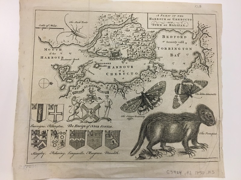
Halifax, Nova Scotia was originally a French colony known as “Acadia,”[1] but Great Britain was awarded the land as part of the peace treaty of 1713 between France and Britain.[2] However, once the British took over the land, the French and Indian tribes in the area formed an alliance, making it difficult for the British to maintain control over the area.[3] Halifax was established in 1749 and was used as a naval base and a seaport.[4] In order to populate the area, Britain enlisted New England settlers to move to Halifax.[5] Even in this map of the Harbor of Chebucto and the town of Halifax, one can already tell that Nova Scotia was not heavily settled by 1750, when the map was made.[6] In fact, the entire colony only had 14,000 colonists by 1770.[7] According to “The World Displayed” written in 1779, the earl of Halifax created incentives for settlers to move to Nova Scotia, giving soldiers and seamen fifty acres of land tax free for ten years and giving more acres depending on the size of each family.[8] Officers and lieutenants were offered even more land.[9] As the account states, upon arriving in Halifax, these families would “be furnished with arms and ammunition as far as should be thought necessary for their defense; with a proper quantity of materials and utensils for husbandry, clearing and cultivating their lands, erecting houses, carrying on the fishery, and such other purposes as might be found proper for their support.”[10] Thus, this is how the town of Halifax was erected and populated.
The inhabitants of Halifax were protected by British army regiments because the surrounding Native American population was so hostile towards the British.[11] As the map shows, not much of the land outside of protected Halifax was being used by the British settlers.[12] This is partly to do with the quality of soil, but also partly to do with the danger posed by the Native Americans, making it impossible for British settlers to leave Halifax unless in a large group for hunting and gathering purposes.[13]
Halifax was a seaport and naval base. One can tell by looking at this map, which pays close attention to the depth of the water, that this map was perhaps used by sailors in the area, not people traveling by foot. Each point, cove, beach, and island is named especially around Cornwallis Island and in Chebucto Harbor. However, in Bedford formerly called Torrington Bay less of the coves and islands are named.[14] This makes sense since this map is specifically of Chebucto and Halifax and most other parts of Nova Scotia were not settled or safe. Halifax became an important naval base during the Seven Years War, which created a “quick circulation of money” within the town.[15] In “The World Displayed,” the writer describes Halifax as a “metropolis.”[16] One reason why Halifax was thought of as a metropolis of sorts was that it produced dried codfish, the “third-most-valuable export from British America, exceeded only by West Indian sugar and Chesapeake tobacco.”[17] He describes the Harbor of Chebucto as “one of the finest in the world,”[18] because of its access to bays on the coastline and its “advantages for fishery.”[19]
It is interesting to see how both the map made in 1750 and this account published in 1779 match up. Although, the map has less on it than is described in the account, the general geography around Halifax and the Harbor described in each seem to match up well. The map also includes drawings of certain insects and wildlife.[20] Since one would not hunt for beetles, butterflies, or porcupine, it could be that this mapmaker simply found those to be the most interesting species or was told about these species and later included them in his map to give someone an idea of what they might find when they arrive in Halifax. It is clear that “The World Displayed” was written for people in England who were curious about the Americas. The writer often compares geography in Nova Scotia to that of England in order to give readers a reference point. For example, he compares the Sandwich River in Nova Scotia to the Thames River in London.[21] He also compares the weather in Halifax to London weather describing the summers in Nova Scotia as “hotter than in England.”[22]
From these accounts and secondary research, it seems that Halifax’s reliance on the British Navy and sea trade would have forced them to stay on the Loyalist’s side. Since their trade relied on trade with Great Britain, it would have been difficult to cut them off from that. Also, being such a small colony made up of soldiers and naval officers, it would have been unlikely that they would have rebelled against the Crown.
[1] Alan Taylor, American Revolutions: A Continental History, 1750-1804 (New York: W.W. Norton & Company, 2016), 19.
[2] Ibid, 41.
[3] Ibid, 19.
[4] Ibid.
[5] Ibid, 145.
[6] Moses Harris, A Plan of the Harbour of Chebucto and Town of Halifax, (1750).
[7] Taylor, American Revolutions, 145.
[8] “Chapter XXV,” The World Displayed, (Dublin: James Williams, 1779), 49.
[9] Ibid.
[10] Ibid, 50.
[11] Ibid, 53.
[12] Moses Harris, A Plan of the Harbour of Chebucto and Town of Halifax, (1750).
[13] “Chapter XXV,” The World Displayed, (Dublin: James Williams, 1779), 230-231.
[14] Moses Harris, A Plan of the Harbour of Chebucto and Town of Halifax, (1750).
[15] Ibid, 54.
[16] Ibid, 55.
[17] Taylor, American Revolutions, 19.
[18] Ibid.
[19] Ibid.
[20] Moses Harris, A Plan of the Harbour of Chebucto and Town of Halifax, (1750).
[21] “Chapter XXV,” 56.
[22] Ibid, 55.