A Shining City Upon a River (Place)
 http://dighist.fas.harvard.edu/courses/2017/hist1002/files/original/7ebc47295cbb5727bb6d41f6c03571a9.pdf http://dighist.fas.harvard.edu/courses/2017/hist1002/files/original/fbade190f81f71376a831de100d93012.pdf
 To people outside of New York State, Albany may have seemed little more than a city with a fort on a river, living in the shadow of the cosmopolitan New York City. In truth, as much as New York City was a hub for goods and information of Mid-Atlantic North America, Albany was an important hub for the colony of New York and the colonies at large. Connected to New York City by the Hudson River, colonists living in Albany would likely have felt as if they lived next door, and may have felt just as important to the development of American independence as New Yorkers did. In the 18th century, there was no faster way to travel than by ship, and all the world had to offer to New York flowed swiftly through its harbor and down the river to this patriotic city.
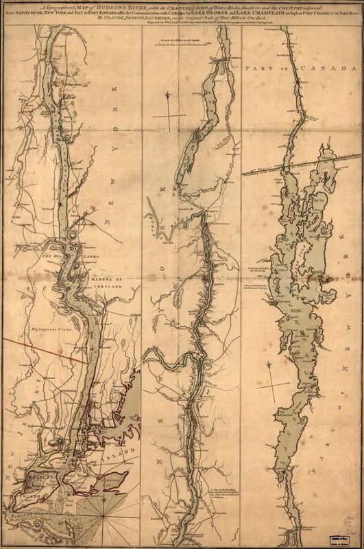
To situate Albany in Britain’s North American colonies, let’s look first to Claude Joseph Sauthier’s topographical map of the Hudson River, one of New York’s principal waterways. It’s relatively easy to pick out landmarks of New York City in the lower-left corner of the map, perched on the mouth of the Hudson with Long Island and Staten Island indicated in large letters. Albany is towards the center of the map, marked with a fort. The map understates the excellent placement of the city which compelled the French, and then the Dutch, to settle there, and the British to take it in the late 17th century. [1][2] This placement allowed for the settlement to flourish, receiving its city charter about a decade later. [3] Not a hundred years later, Albany and its surrounding county had ballooned to nearly a third of the population of the New York colony. [4] Clearly, the map understates size as well. Of course, there’s only so much we can learn about a city from a map of the nearby waterways. Let’s look at Albany from a local perspective to understand how its residents considered their city.
Albany’s newspaper, The New-York Gazetteer or Northern Intelligencer, shows the flow of information and goods through the city. Boasting news from as close as the Albany’s city hall and Schenectady’s Dutch church, as far north as Boston, as far south as Richmond, and far east as The Hague and Vienna, this is a paper one would expect to find in a cultured, well-established newspaper, further evidence that Albany is just that sort of city.
Our featured advertisement gives us an image of the goods that come to Albany and of the citizens of Albany that might purchase them. The merchant, Maus R. Van Vranken, advertises the articles as having “just come to hand”, indicating that they had likely just arrived in the city via the Hudson. Van Vranken is a local man, however; his store is located near General Ten Broeck, Albany’s current mayor. [5] As we examine the names of other Albany locals in the newspaper, we see that Dutch surnames are indeed quite ubiquitous. This, and references to the Dutch church as the center of the city show us that this British colony has remained connected with its Dutch roots. [6] It’s possible that this augmented the city’s willingness to part from the empire. For sale, we largely see manufactured textiles and clothing, which are likely imported from Europe. We also see products of the West and East Indies: Jamaican spirits, sugar, spices. Van Vranken notes that he accepts payment in cash or in grain. We see from this that he sells to a diverse group, carrying luxuries like satin and silver for the wealthy and various cottons and buttons for the working class, accepting several modes of payment so that those without cash can still do business. Thus, we see the makings of a city, where people of all classes gather to do business and share information and ideas fresh from New York Harbor.
Albany was a lively city in the mid 18th century, participating in the international flow of goods and information as actively as New York City did. In a time when ideas traveled fastest by water, Albany’s citizens would feel themselves become as much an epicenter of revolution as New York City’s did, with many prominent New Yorkers feeling quite at home in both places. [7][8] Strategic placement notwithstanding, Albany is far more than a fort on a river in 18th century New York.
Word Count: 734
- Cuyler Reynolds, Albany chronicles: A history of the city arranged chronologically. From the earliest settlement to the present time (Albany, NY: J. B. Lyon Co., 1906), v.
- Ibid., 74.
- Ibid., iii.
- Ibid., 269.
- Ibid., 353.
- Ibid.
- Ibid., 273
- Ibid., 353